
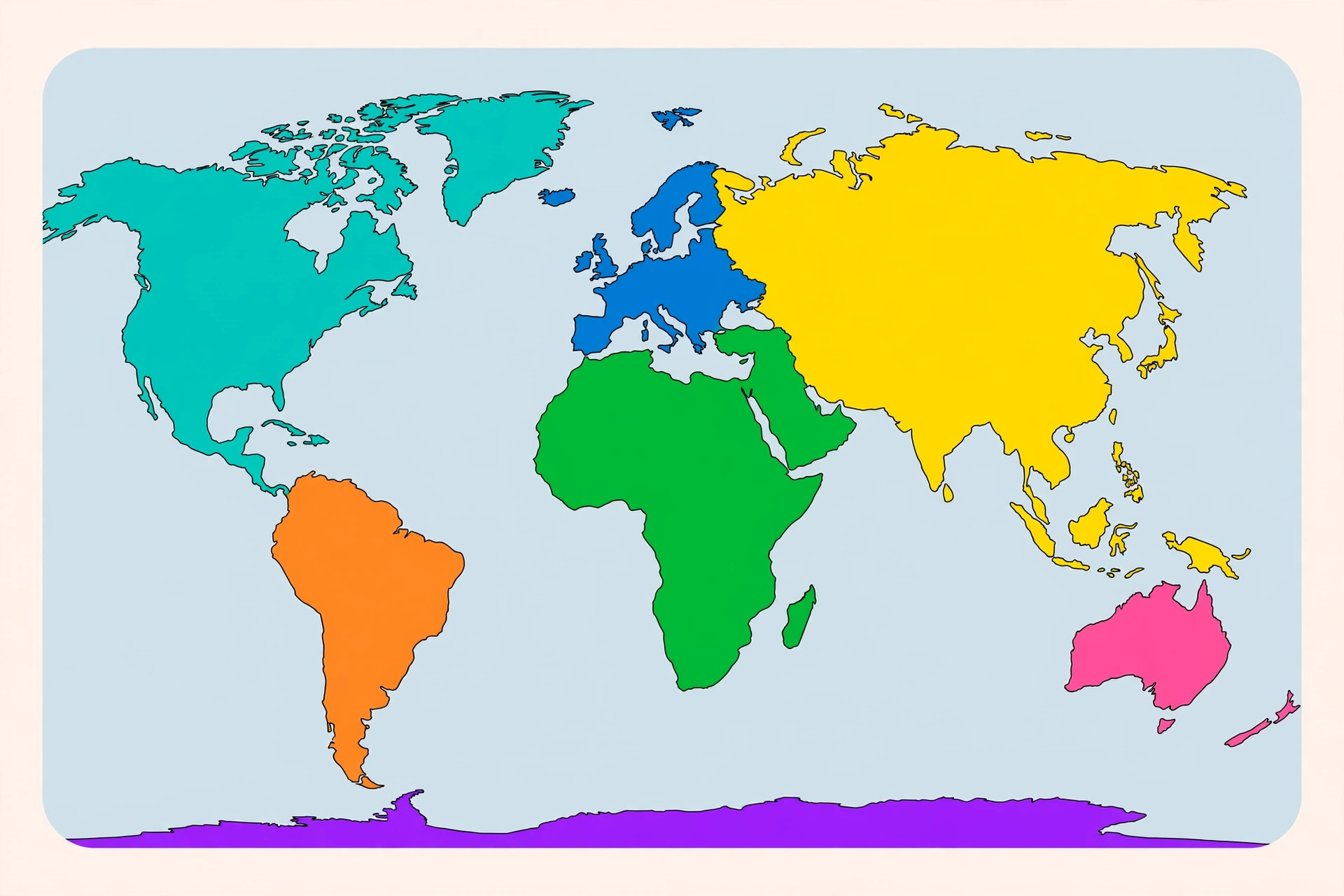
Every map you have ever seen divides the world into continents, yet the seven we learn in school — Africa, Antarctica, Asia, Australia, Europe, North America, and South America — owe more to history and convention than to strict science. Geographers do not even fully agree on how many continents exist: depending on where you live, the answer can range from four to seven. This guide to the geography of our planet breaks down each of the seven continents by size and population, highlights their most important countries and landmarks, and explains why the number seven is less settled than your textbook made it sound.
What Defines a Continent?
Unlike countries, which have internationally recognized borders, there is no single official scientific definition of a continent. The most common working definition describes a continent as a large, continuous expanse of land, ideally separated from others by water — but Europe and Asia share one enormous landmass, and North and South America are joined by a narrow isthmus, so the definition quickly bends.
Geologists sometimes prefer a different yardstick: continental crust. The Earth's crust comes in two types — thin, dense oceanic crust under the seas and thicker, lighter continental crust under the land — which is why places like the United Kingdom and Sri Lanka still sit on the same continental crust as their mainland neighbors.
In practice, the continents we name blend physical geography with culture and history. Europe is separated from Asia not by an ocean but by a boundary drawn roughly along the Ural Mountains and the Caucasus — which is why the debate over how many continents exist has never been purely scientific.
The 5, 6, or 7 Continent Debate
Most English-speaking countries — including the United States, the United Kingdom, Canada, and Australia — teach the seven-continent model. Elsewhere, other models are standard, and each is internally consistent:
- Seven continents: Africa, Antarctica, Asia, Australia, Europe, North America, South America. Taught in the US, UK, Canada, Australia, India, and China.
- Six continents (Americas combined): North and South America form a single continent called America. Standard across most of Latin America and parts of Europe.
- Six continents (Eurasia combined): Europe and Asia form one continent, Eurasia. Common in Russia and some Eastern European countries.
- Five continents: Both mergers at once. This is the model behind the five Olympic rings, representing the five inhabited continents — Antarctica is left out.
- Four continents: Africa merges with Eurasia into "Afro-Eurasia," on the argument that the Suez Canal is too small a cut to split a continent.
None of these models is "wrong" — they simply weigh physical landmasses and cultural regions differently. For consistency, this article uses the seven-continent model taught across the US, UK, Canada, and Australia.
The Seven Continents at a Glance
Ranked by land area, the seven continents span an extraordinary range — from Asia, which covers nearly a third of all land on Earth, to Australia, the only continent that is also a single country.
1. Asia — The Giant
Asia is by far the largest and most populous continent, covering about 44.6 million square kilometers (roughly 30% of Earth's land) and home to around 4.8 billion people — about 60% of all humanity. It stretches from the Arctic coast of Siberia to tropical Indonesia and from Turkey to Japan.
Notable countries include China and India, the world's two most populous nations, plus Japan, Indonesia, and Saudi Arabia. Asia's landmarks read like a greatest-hits list of the planet: Mount Everest, the highest peak on Earth at 8,849 meters; the Great Wall of China; the Himalayas; and the deserts of Arabia and the Gobi. Every major world religion — Hinduism, Buddhism, Judaism, Christianity, and Islam — originated here.
2. Africa — The Cradle of Humanity
Africa covers about 30.4 million square kilometers and has roughly 1.5 billion people, making it the second-largest continent by both area and population. It is the only continent crossed by both the Equator and the Prime Meridian, and it is widely regarded as the birthplace of humankind.
Notable countries include Nigeria, Egypt, South Africa, Ethiopia, and Kenya. Africa's landmarks are legendary: the Sahara, the largest hot desert on Earth; the Nile, traditionally considered the world's longest river; the Serengeti's great wildlife migrations; and Mount Kilimanjaro, Africa's highest peak. The continent also holds enormous linguistic diversity, with well over 2,000 distinct languages spoken.
3. North America — The Third Largest
North America spans about 24.7 million square kilometers with a population of around 600 million people. It stretches from the Arctic islands of northern Canada to the tropical tip of Panama, encompassing huge variations in climate — from Greenland's ice cap to Central American rainforests.
Notable countries include the United States, Canada — the world's second-largest country by area — and Mexico, along with the nations of Central America and the Caribbean. Famous landmarks include the Grand Canyon, Niagara Falls, Denali (North America's highest peak), and Yellowstone's geysers.
4. South America — The Continent of Superlatives
South America covers about 17.8 million square kilometers and has roughly 440 million residents. Shaped like a great triangle tapering toward Cape Horn, it contains an astonishing share of the world's natural wonders.
Notable countries include Brazil — which occupies about half the continent's area — Argentina, Colombia, Peru, and Chile. South America holds the Amazon, the largest rainforest and river system on Earth; the Andes, the longest mountain range in the world; the Atacama Desert, the driest non-polar place on the planet; and the ancient Incan citadel of Machu Picchu.
5. Antarctica — The Frozen Continent
Antarctica is the fifth-largest continent at about 14.2 million square kilometers — larger than Europe and Australia combined — yet it has no permanent population. Only around 1,000 to 4,000 scientists and support staff live there at any time, mostly in research stations, with numbers swelling during the southern summer.
No country owns Antarctica. Under the Antarctic Treaty of 1959, the continent is reserved for peaceful scientific research, and military activity and mineral mining are banned. Key features include the South Pole, Vinson Massif (its highest peak), and ice averaging over 2 kilometers thick — holding about 70% of the world's fresh water. It is the coldest, driest, and windiest continent, with the lowest temperature ever recorded on Earth: −89.2°C at Vostok Station in 1983.
6. Europe — Small but Mighty
Europe is one of the smallest continents at about 10.2 million square kilometers, yet it is home to roughly 745 million people — one of the highest population densities of any continent. Despite its size, Europe has shaped world history, science, and culture out of all proportion to its area.
Notable countries include Germany, France, the United Kingdom, Italy, and Spain. Landmarks range from natural wonders like the Alps and the fjords of Norway to human achievements like the Eiffel Tower, the Colosseum, and the historic cities of Rome, Paris, and Athens.
7. Australia — The Island Continent
Australia is the smallest continent at about 8.6 million square kilometers (including the islands of Oceania) and has a population of roughly 45 million across the broader Oceania region. It is the only continent occupied by a single country — Australia — which is why the continent is sometimes called Australia and sometimes Oceania to include Pacific island nations.
Notable countries include Australia, New Zealand, Papua New Guinea, and Fiji. Its landmarks are unmistakable: the Great Barrier Reef, the world's largest coral reef system; Uluru, the great red sandstone monolith sacred to Indigenous Australians; and the Sydney Opera House. Australia is also the flattest and, after Antarctica, the driest inhabited continent.
Largest and Smallest: Continent Records
- Largest continent by area: Asia (44.6 million km²)
- Smallest continent by area: Australia/Oceania (8.6 million km²)
- Most populous continent: Asia (~4.8 billion people)
- Least populous continent: Antarctica (no permanent residents)
- Highest average elevation: Antarctica, thanks to its colossal ice sheet
- Most countries: Africa, with 54 recognized sovereign states
- Most densely populated: Asia, home to the world's two most populous nations
Why Continents Still Matter
Continents are more than lines on a map. They shape everything from climate systems and biodiversity to trade routes, languages, and cultures. Understanding the seven continents — their staggering differences in size, their billions of inhabitants, and even the debate over how many there are — is the foundation of all geography.
Curious how a single planet can run on so many different clocks? Read our companion guide, Time Zones Explained: Why the World Has Different Times, to see how humanity divided the spinning Earth into 24 hours.